This page is under construction, Figures 3, a and b, coming soon. For high quality figures, suitable for reproduction, contact Chris Andronicos.
The following abstract has been sent to the SNORCLE Workshop, scheduled for March 7-9, 1997, University of Calgary.
For additional information see links to SNORCLE and LITHOPROBE
Evidence for late (Miocene?) extension across the Coast Mountains

- Lincoln S. Hollister and Triparna Das
Department of Geosciences, Princeton University, Princeton, NJ 08544 - John Diebold
- Lamont Doherty Earth Observatory of Columbia University, Palisades, NY 10964
- Igor B. Morozov and Scott B. Smithson
- Department of Geology and Geophysics, University of Wyoming, Laramie, WY 82071
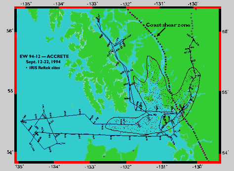
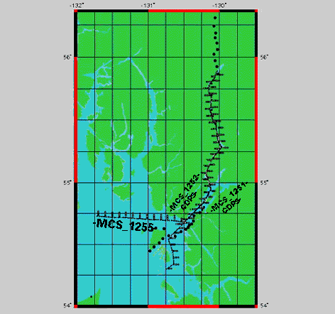
The ACCRETE project (Fig. 3a; ) acquired MCS seismic reflection profiles along Portland Canal on the Alaska-British Columbia border and a loose grid of lines over the northern end of the Tertiary Queen Charlotte Basin including east Dixon Entrance (Fig. 3b). In addition, wide angle reflection and refraction data were collected by 60 seismometers spaced at 3-5 km intervals along Portland Canal and in-lineextensions to the northeast and southwest.
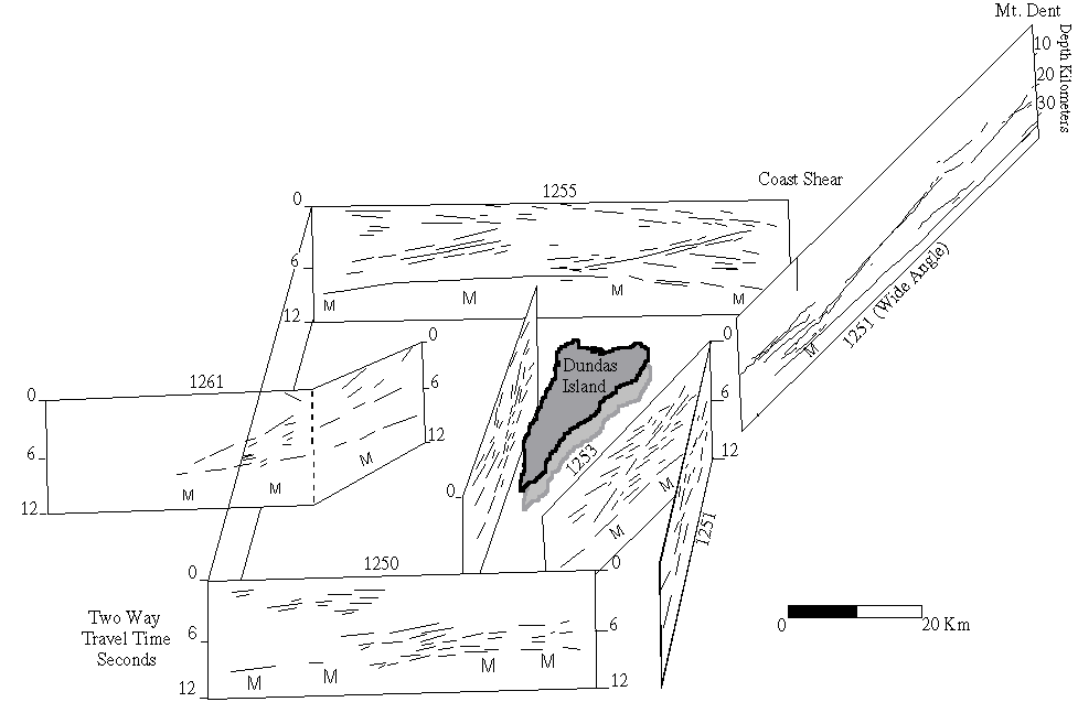
One of our results was the finding of at least three distinctive south to west dipping reflecting bands between Hecate Strait and Stewart (Fig. 4). One band appears to cross the vertical projection of the Coast shear zone at about 25 km depth and can be traced to a depth of about 15 km under Mt. Dent, some 60 km northeast of the Coast shear (Figs. 2a, 3). It was clearly imaged in the wide angle data. A second extends from about 10 km depth at the Coast shear to about 3 km above the Moho under east DixonEntrance, for line 1255, and under Dundas Island for line 1253. The third is parallel to the second, but about 40 km further to the west. The reflecting zones have these features:
- They are imaged in north-south to east-west transects and therefore are dipping southwesterly; there is 3-d control for the two west of the Coast shear (Fig. 4).
- At their southwest ends, they merge with lower crustal reflecting horizons above where the Moho shallows.
- There are no ductile structures mapped on the surface that dip south to west.
- Where the two western bands project to about 10 km depth, an extensional structure bounded by brittle faults extends to the surface. These grabens are clearly imaged in the MCS data. East of Mt. Dent (Figs. 1, 3) is an extensional structure extending from Terrace to at least the Recent lava flow at New Aiyansh (Woodsworth, pers. com.); the eastern reflector may project to below this structure.
We conclude that these structures are extensional and younger than 50 Ma, and probably Miocene or younger (1) because two terminate under young grabens, (2) because the eastern band appears to cut the Coast shear zone, a feature as young as 55 Ma, (3) because the eastern band is straight and coherent across the central gneiss complex which was deformed and intruded by plutons as young as 50 Ma, and (4) because their eastern terminations are approximately at the present-day brittle-ductile transition. If they are young ductile features, they would not reach thepresent surface; rather, they would terminate at steep brittle extensional faults as they appear to do. The Moho shallowings are also consistent with a young extensional overprint on the Coast orogen. The seismic data are still being processed and analyzed, andtherefore these conclusions are preliminary; but the weight of evidence points to late extension, probably Miocene, affecting the western cordillera from west Dixon Entrance (Rohr and Dietrich, 1991) at least as far as the eastern side of the Coast Mountains.
 Return to Accrete Home Page