![]()
![]()
![]()
![]()
![]()
![]()
![]()
![]()
![]()
![]()
![]()
![]()
![]()

![]()
![]()
![]()
![]()
![]()
![]()
![]()
![]()
![]()
![]()
![]()
![]()
![]()
Results from ACCRETE, 1994 - 2003
The results from ACCRETE are given in the 26 peer-reviewed articles listed below. Many of the articles, including figures, can be obtained electronically from the journal web sites, and/or from the author web sites. The text below summarizes the major results.
Andronicos, et al (1999) showed that dextral transpression occurred across the Coast Mountains batholith during the time of proposed northwards translation of Baja BC (mid-Cretaceous-Paleocene). Truncations of seismic reflectors, contrasts of physical properties, and offset of Moho (Morozov et al, 1998, 2001, 2003) showed that a nearly vertical structure passes through the crust near the Coast shear zone. The combined results of geologic and seismologic studies therefore suggest that a crustal scale dextral, transcurrent, strike-slip shear zone occurs within the Coast Mountains batholith, and the present Coast shear zone is near the western boundary of this dextral shear zone. Based on its size, age, and sense of displacement, this dextral shear zone could represent a section of the Baja BC fault system. Motion across this shear zone ceased by 58 Ma.
A major and unanticipated result from ACCRETE was to show that crustal scale extension of the Coast Mountains batholith occurred during the Eocene. This extension was concurrent with intrusion of large volumes of Eocene granodiorite to diorite plutons (Hollister and Andronicos, 1997; Chardon, et al, 1999; Andronicos, et al, 2003). It was also concurrent with 15-20 km of exhumation. Thanks to ACCRETE and a rapidly expanding awareness of the large region affected by the Eocene magmatism and extension, it is becoming increasingly apparent that this Eocene episode was an important event for forming the continental crust of western North America.
Hollister et al (2004) showed that the intense episode of magmatic accretion between 50 and 60 Ma in the Coast Mountains (Andronicos et al, 2003) led to reheating of portions of the Baja BC terrane. This reheating reset magnetic remanence directions in the older rocks when ilmenite exsolved from ilmenohematite, leading to lamellar magnetism. Although the reset directions are consistent with what would be expected from tilting or folding (Butler et al, 2001; 2002), Hollister et al (2004) showed that older magnetic remanence directions were reset towards those corresponding to the Eocene magnetic pole. These results strengthen the Baja BC hypothesis.
The strong S-wave generation in the ACCRETE experiment provided S-wave coverage comparable to that of P- waves (Morozov et al, 2001). The S-wave generation was probably produced by mode conversion at the glacially polished interface between unconsolidated, poorly sorted glacial sedimentary deposits and the underlying bedrock. This is a feature presumably unique to where glaciers once extended from the continental margin to the sea. The unusual S-wave coverage allowed us to obtain a model of Vp/Vs velocity ratios, from which much better constraints on lower crustal lithologies could be interpreted than from a Vp model alone (Morozov et al, 2003).
The geophysical experiments showed that the thickness of continental crust under the Coast Mountains batholith is only 31-32 km (Morozov et al, 1998; Hammer et al, 2000). This was a first-order surprise that is contributing to the multitude of hypotheses and studies regarding extension across western Canada.
The seismic velocity structure indicated a lower crust made of a mixture of mafic garnet granulite and restite. The mafic garnet granulite is the metamorphic equivalent of gabbro at the present P-T conditions at the base of the crust, and the restite is what remains after extraction of granitic melt (Morozov, et al, 2003). We proposed that these lithologies represent what remained after basalt liquid had intruded the lower crust and had partially melted it. Mixing of basalt and melted crust probably resulted in formation of the plutons of the Coast Mountains batholith.
The average crustal velocity under the Coast Mountains batholith resembles that of average continental crust when the loss of 10 - 20 km by unroofing is considered. Unroofing by that amount was proposed by Hollister (1982) and confirmed and refined by Andronicos, et al (2003).
A program of educational outreach evolved from the extensive permitting process necessary for the marine seismic survey (Hollister, 1995, 1997, 1998). A geological guide for the interested public is in preparation. Help for producing this guide has come from a wide range of local citizens, and it has been extensively tested with groups representative of potential users.
![]()
Publications:
Published or in press articles based on ACCRETE :
1. Hollister, L.S., 1995, Talking to the public - an example. GSA Today 5, no. 2, 36
2. Hollister, L.S., and Andronicos, C.L., 1997, A candidate for the Baja British Columbia fault system in the Coast Plutonic Complex. GSA Today 7, no.11, p. 1-7.
3. Hollister, L.S., 1997, ACCRETE discussion paper. Catalyst 40, no.2, 13-16.
4. Hollister, L.S., 1998, Learning lessons from science experiments. EOS, 79, 31.
5. Morozov, I.B., Smithson, S.B., Hollister, L.S., and Diebold, J.B., 1998, Wide-Angle seismic imaging across accreted terranes, southeastern Alaska and western British Columbia: Tectonophysics, v. 299, p.281-296.
6. Andronicos, C.L., Hollister, L.S., Davidson, C., and Chardon, D., 1999, Kinematics and tectonic significance of transpressive structures within the Coast Plutonic Complex, British Columbia: Journal Structural Geology 21, p. 229-243.
7. Chardon, D., Andronicos, C. L., and Hollister, L. S., 1999, Large-scale transpressive shear zone patterns and displacements within magmatic arcs: The Coast Plutonic Complex, British Columbia. Tectonics 18, 278-292.
8. Klepeis, K. A., and Crawford, M. L., 1999, High-temperature arc-parallel normal faulting and transtension at the roots of an obliquely convergent margin. Geology 27, 7-10.
9. Evenchick, C. A., M. L. Crawford, V. J. McNicoll, L. D. Currie, and P. B. O'Sullivan, 1999, Early Miocene or younger normal faults and other Tertiary structures in west Nass River (103P) map area, northwest British Columbia, and adjacent parts of Alaska, in Current Research, Pap. Geol. Surv. Can., 99-1A.
10. Thomas, J.B., and Sinha, A.K., 1999, Field, geochemical, and isotopic evidence for magma mixing and assimilation and fractional crystallization processes in the Quottoon igneous complex, northwestern British Columbia and southeastern Alaska. Canadian Journal Earth Science 36. 819-831.
11. Crawford, M.L., Klepeis, K.A., Gehrels, G., and Isachsen, C., 1999, Batholith emplacement at mid-crustal levels and its exhumation within an obliquely convergent margin. Tectonophysics 312, 57-78.
12. Scheidhauer, M., Trehu, A.M., and Rohr, K.M.M., 1999, Multi-channel seismic reflection survey over the northern Queen Charlotte Fault. Geological Survey of Canada Open File No. 99-3779, 7 pp.
13. Hammer, P.T.C., Clowes, R.M., and Ellis, R.M., 2000, Crustal structure of NW British Columbia and SE Alaska from seismic wide-angle studies: Coast Plutonic Complex to Stikinia. J. Geophys. Res. 105, 7961-7981.
14. Rohr, K.M.M., Scheidhauer, M., and Trehu, A.M., 2000, Transpression between two warm mafic plates: the Queen Charlotte Fault revisited. J. Geophys. Res. 105, 8147-8172.
15. Crawford, M.L., Crawford, W.A., and Gehrels, G.E., 2000, Terrane assembly and structural relstionships in the eastern Prince Rupert quadrangle, British Columbia. Geological Society of America, Special Paper 343, 1-22.
16. Hollister, L.S., and Andronicos, C.L., 2000, The Central Gneiss Complex, Coast Mountains, British Columbia. Geological Society of America, Special Paper 343, 45-59.
17. Morozov, I.B., Smithson, S.B., Chen, J., and Hollister, L.S, 2001, Generation of new continental crust and terrane accretion in southeastern Alaska and western British Columbia: constraints from P- and S- wave wide-angle data (ACCRETE). Tectonophysics 341, 49-67.
18. Butler, R.F., Gehrels, G.E., Crawford, M.L. and Crawford, W.A., 2001, Paleomagnetism of the Quottoon plutonic complex in the Coast Mountains of Bitish Columbia and southeastern Alaska: Evidence for tilting during uplift. Canadian Journal of Earth Sciences 38,
19. Gehrels, George E., 2001, Geology of the Chatham Sound Region, Southeast Alaska and Coastal British Columbia. Canadian Journal of Earth Sciences 38, 1579-159.
20. Butler, R.F., Gehrels, G.E., and Kodama, K.P., 2001, A moderate translation alternative to the baja BC hypothesis. GSA Today 11, no. 6, 4-10.
21. Butler, Robert F.; Gehrels, George E.; Baldwin, Suzanne L.; Davidson, Cameron, 2002, Paleomagnetism and geochronology of the Ecstall pluton in the Coast Mountains of British Columbia: Evidence for local deformation rather than large-scale transport. J. Geophysical Research 10.1029/2001JB000270
22. Chardon, D., 2003, Strain partitioning and batholith emplacement at the root of a transpressive magmatic arc. J. Structural Geology 25, 91-107.
23. Morozov, I.B., Christensen, N.I., Smithson, S.B., and Hollister, L.S., 2003, Seismic and laboratory constraints on crustal formation in a former continental arc (ACCRETE, southeastern Alaska and western British Columbia). J. Geophysical Research. 108(B1), 2041, doi:10.1029/2001JB001740.
24. Davidson, C., Davis, K.J., Bailey, C.M., Tape, C.H., Singleton, J., and Singer, B., 2003, Age, origin, and significance of brittle faulting and psuedotachylyte along the Coast shear zone, prince Rupert, British Columbia. Geology 31, 43-46.
25. Andronicos, C.L., Chardon, D.H., Hollister, L.S., Gehrels, G.E., and Woodsworth, G.J., 2003, Strain partitioning in an obliquely convergent orogen, plutonism, and synorogenic collapse: The Coast Mountains batholith, British Columbia, Canada. Tectonics 22, 2, 1012, doi:10.1029/2001TC001312.
26. Hollister, L.S., Hargraves, R.B., James, T.S., and Renne, P.R., 2004, The Paleomagnetic Effects of Reheating the Ecstall Pluton, British Columbia. Earth Planetary Science Letters 221, 397-407.
27. Hollister, L.S., C.L. Andronicos, 2006, The formation of new continental crust in western British Columbia during transpression and transtension. Earth and Planetary Science Letters 249, 29-38. (pdf file)
28. Li, Hongyan, Morozov, I.B., and Smithson, S.B., 2008, 3D seismic analysis of the Coast Shear Zone in SE Alaska and Western British Columbia: Broadside analysis of ACCRETE wide-angle data. Tectonophysics 448, 20-32. (pdf file)
29. Hollister, L.S., Diebold, J., and Das, T., 2008, Whole crustal response to late Tertiary extension near Prince Rupert, British Columbia. Geosphere v.4, no. 2, 360-374. doi: 10.1130/GES000144.1 (pdf file)
![]()
Other Printed Information:
The Jan, 1998, EOS article "Learning Lessons from Science Experiments" is reproduced here.
A definition of the Coast shear zone is available from: Structural Geology and Tectonics Division (GSA) Newsletter, 1998, v. 17, no. 1
![]()
The ACCRETE program is a collaborative endeavor to determine how continents grow by magmatic and terrane accretion, and to investigate the relative roles of these processes. The focus is on the Coast Mountains orogen of southeast Alaska and British Columbia. The central segment of the Coast Mountains orogen is an ideal laboratory because (1) we have acquired geophysical data across it that are exceptional in quality and quantity, (2) rocks presently exposed at the surface were formed at mid-crustal levels, and (3) we can project mid-crustal geological features from the surface down-dip into the seismic section. Combining geophysical and geological data we will construct a section across the orogen from the surface to the upper mantle. Besides providing answers to fundamental questions regarding continental growth at convergent to transpressive plate margins, we also address major questions regarding the overall tectonic history of western North America.
ACCRETE was funded from the Continental Dynamics program of NSF,
for 1996-1999. The funds were for continued processing of our high quality
seismic data and for geologic and geochemical studies along the seismic
transect. There are 9 PIs at 8 institutions.
![]()
 Click on image for larger scale.
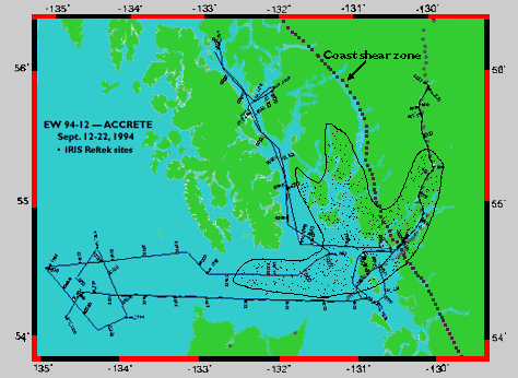
Above: Ship tracks for the EWING cruise EW 9412. Unreadable numbers on lines are common depth points (CDPs). Approximate location of Coast shear zone is shown for reference. The shaded area schematically shows locations of wide-angle midpoints for which the Univ. of Wyoming and Univ. of British Columbia teams observed Moho reflections. Track lines between 133 and 135 degrees West cover the Queen Charlotte transform fault (contact Rohr or Trehu).
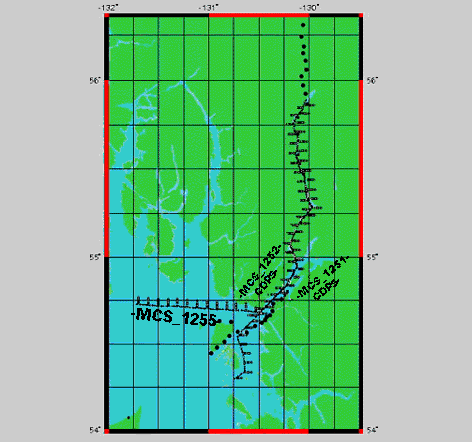
Below: Ship track of EWING within the ACCRETE core corridor, showing lines 1251, 1252, and 1255. Line 1251 was shot at 20 second intervals from south to north end of Portland Canal, and at 60 second intervals on return to the entrance to Portland Inlet. Line 1255 was shot from the entrance to Portland Inlet to the west at 20 second intervals. Unreadable numbers along lines are CDPs.
 Click on image for larger scale.
![]()
Lincoln S. Hollister (petrology and geology) is lead principal investigator, and Princeton University is the lead institution.
Maria Luisa Crawford (petrology and geology), Cameron Davidson (structure and petrology), George Gehrels (U-Pb dating), and Krishna Sinha (igneous geochemistry).
Robert Butler (geophysics) Nikolas Christensen (rock physics), John Diebold (multichannel seismic (MCS)), Scott Smithson (Reftek seismic).
Chris Andronicos (structural petrology), Dominique Chardon (structural geology and tectonics), Keith Klepeis (structural geology), Igor Morozov (Reftek seismic), Margi Rusmore (structural geology), and Anne Trehu (MCS for Queen Charlotte fault).
At Geological Survey of Canada: Carol Evenchick (field studies), Kristin Rohr (MCS for Queen Charlotte fault and Dixon Entrance Tertiary basins), and Glenn Woodsworth (field studies).
At Univ. of British Columbia: Robert Ellis, Phil Hammer, Ron Clowes (processing and interpretation of data from Refteks placed north of Stewart).
![]()
For questions or comments relating to this web page please contact the Webmaster.
Last update 03/27/08